


Cap canaille

domi06
User
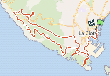

Length
18.7 km

Max alt
380 m

Uphill gradient
646 m
Km-Effort
27 km

Min alt
1 m

Downhill gradient
647 m
Boucle
Yes
Creation date :
2022-04-06 06:44:23.396
Updated on :
2024-07-19 15:14:25.591
8h14
Difficulty : Very difficult

FREE GPS app for hiking
 SityTrail
IGN / Geographical institutes
SityTrail Plus
The world is yours!
About
Trail Walking of 18.7 km to be discovered at Provence-Alpes-Côte d'Azur, Bouches-du-Rhône, La Ciotat. This trail is proposed by domi06.
Positioning
Country:
France
Region :
Provence-Alpes-Côte d'Azur
Department/Province :
Bouches-du-Rhône
Municipality :
La Ciotat
Location:
Unknown
Start:(Dec)
Start:(UTM)
712152 ; 4783824 (31T) N.
Comments